Thirty-six years ago today, the ground beneath northern and central Luzon shook with a violence Filipinos of that generation have never forgotten.
At exactly 4:26 in the afternoon of July 16, 1990, a magnitude 7.8 earthquake struck—the strongest and most destructive to hit the Philippines in two decades, according to PHIVOLCS.
The epicenter was near the town of Rizal in Nueva Ecija, at a depth of 28 kilometers, with shaking lasting approximately 45 seconds.
Maximum intensity reached VIII on the Modified Rossi-Forel scale, equivalent to VIII to IX on the Modified Mercalli scale.
Four regions in north and central Luzon bore the full force of the disaster, with the cities of Baguio, Dagupan, Cabanatuan, and San Jose suffering the heaviest damage.
According to the National Disaster Coordinating Council as of November 14, 1990, the earthquake killed 1,283, injured 2,786, and left 321 missing, with about 1.25 million Filipinos affected.
Baguio City, the Philippines’ summer capital in the Cordillera mountains, became the defining image of the disaster.
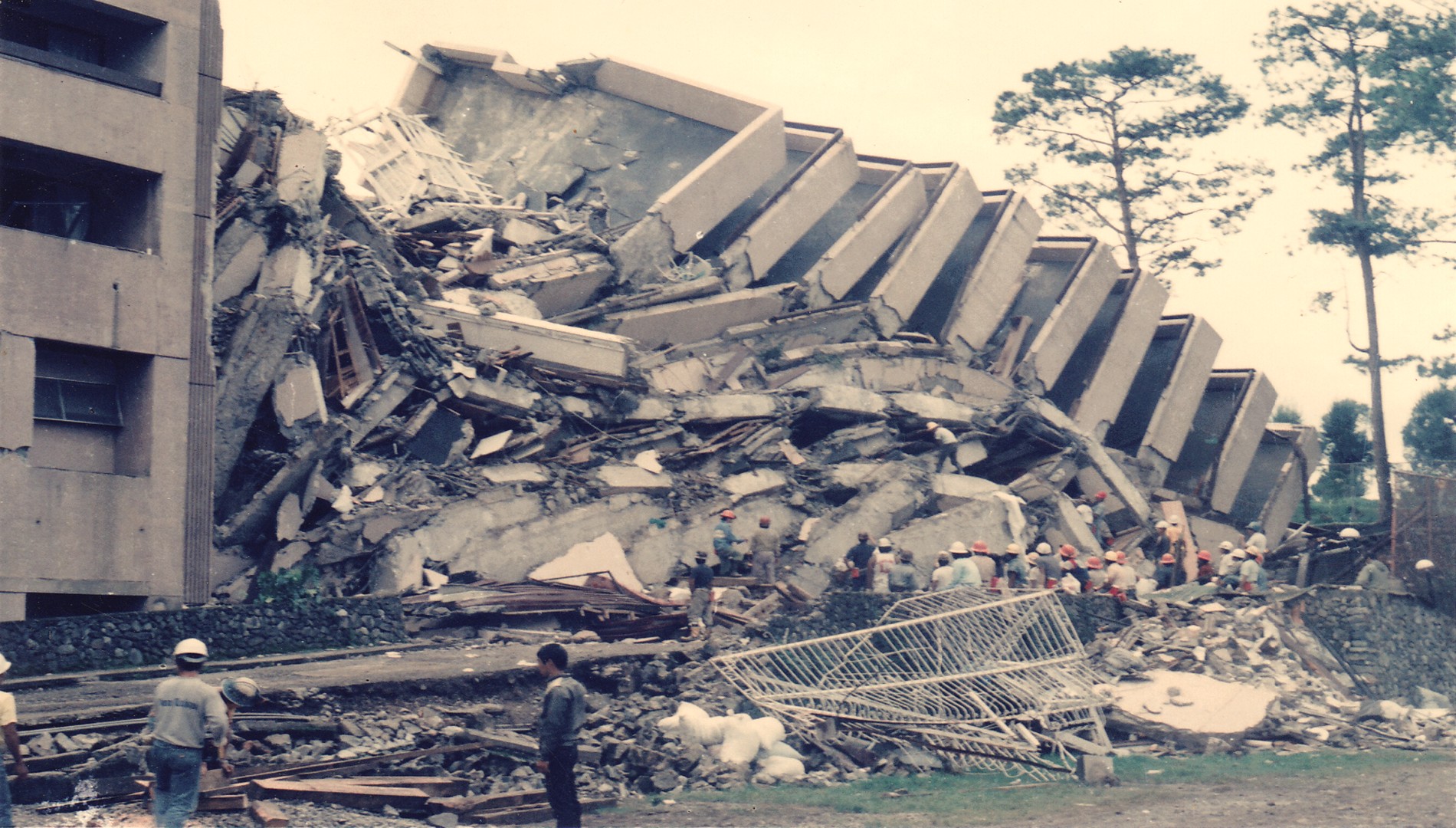
Twenty-eight buildings collapsed across the city, including the iconic 12-storey Hyatt Terraces Baguio, whose terraced front wing pancaked into the lobby, killing at least 80 people—50 guests and 30 employees.
In Cabanatuan, the six-story Christian College of the Philippines building collapsed during school hours, killing around 154 students and teachers.
Some survivors later died of dehydration because rescue teams, lacking heavy equipment to cut through concrete, could not pull them out in time.
The quake unleashed a cascade of geologic disasters—surface faulting produced a 125-kilometer ground rupture from Dingalan, Aurora to Kayapa, Nueva Vizcaya, along the Philippine Fault and the Digdig Fault.
Landslides affected Nueva Ecija, Nueva Vizcaya, and Benguet, with effects most intense near areas traversed by the ground rupture, road cuts, and steep slopes devoid of vegetation, according to PHIVOLCS.
Liquefaction was particularly pronounced in the provinces of Tarlac, Pangasinan, and La Union—most visibly in Dagupan City, where buildings sank as much as one meter into the ground.
NEDA estimated total actual damages to public infrastructure, facilities, and private properties at more than ₱18.7 billion.
Baguio was isolated from the rest of the country for the first 48 hours after the quake, with roads blocked and Loakan Airport limited to helicopter access.
This anniversary comes just weeks after the Philippines was reminded again of its seismic vulnerability, when a magnitude 7.8 earthquake struck 32 kilometers west of Maasim, Sarangani on June 8, 2026, at 7:37 AM.
The Sarangani quake shook the ground for approximately 70 seconds, killed 94 people, injured 1,316, and left 18 missing, with infrastructure damage reaching ₱1.46 billion and the Department of Education separately estimating ₱13 billion in classroom damage.
The 2026 quake matched the 1990 disaster in magnitude but was far less deadly—its epicenter was offshore along the Cotabato Trench at a depth of 33 kilometers, not directly beneath a densely populated landmass as in 1990.
PHIVOLCS Director Dr. Teresito Bacolcol said the June 8 earthquake originated from the Cotabato Trench—one of six active underwater trenches surrounding the Philippines, all capable of generating magnitude 8 and above earthquakes—and stressed that no technology currently exists to predict when the next one will strike.
“Earthquakes are random events, and as of now, there is no technology yet that can tell us exactly when an earthquake would happen, the exact day, the exact time,” Bacolcol told DZRH News program Special on Saturday on June 13.
He said the West Valley Fault, for example, is known to move every 400 to 600 years and last ruptured in 1658—placing its next possible movement anywhere between 2058 and 2258.
“If we consider the lower limit, which is 400 years, 1658 plus 400 years, that would be 2058. But we do not know exactly. It could be earlier or it could be later,” Bacolcol said.
On the question of preparedness, Bacolcol said duck-cover-hold—the standard earthquake safety protocol taught in drills—is not enough on its own if the building a person is inside is not structurally sound.
“Kahit mag-duck, cover, and hold tayo, kahit na-master na natin ‘yung duck, cover, and hold, kapag gumuho ang maliit na bahay natin, hindi pa rin gaano effective,” he said, calling for strict compliance with the National Building Code as the most important layer of protection against seismic disasters.
“Preparedness is not just the business of our institute or business of OCD or NDRRMC, it is everyone’s collective duty to prepare,” Bacolcol said—a message that carries the same urgency today as it did 36 years ago, when the ground shook and the buildings fell.